(the price includes VAT)
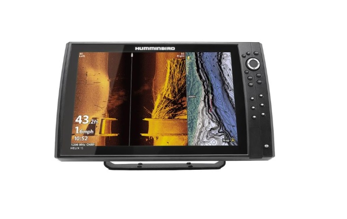
Equipped with the latest generation of MEGA Side + Imaging technology, the HELIX 9x CHIRP MEGA SI + GPS G4N lets you see the underwater world like never before, with crystal clear 200-foot views on both sides of your boat. You will now see 20% more information on the sonar screen than with previous technology.
Greek Menu – CHIRP 150-220 kHz Depth Sounder with 28-250 kHz capability – CHIRP MEGA DI+ 435-535, 800-860 & 1100-1200 kHz – Beam range 25º-42º,75º, 45º & 75º at 200/455/800/ 1200 kHz – 1000W RMS – Maximum depth 305m with capability up to 1067m, 122m DI+ (455kHz), 38m DI+ (800kHz), 61m DI+ (1200kHz) – Built-in high-resolution World map – GPS, EGNOS & GLONASS system – Built-in antenna GPS 10Hz – Accepts Navionics+ & Platinum+ mapping – Color TFT screen 9″ (22.8cm) 65000 colors with a resolution of 1024H X 600V pixels – Includes a temperature sensor in the transmitter – Depth indicator in meters, feet, fathoms – 2750 reference points, 45 courses, 50 tracks with 2000 points each – Ability to save navigation data on a microSD card – Ability to record photos on a microSD card – Built-in AutoChart Live – Illuminated LED display – Ethernet port, NMEA 2000, Bluetooth & Wi-Fi – 2 year warranty.
TECHNICAL CHARACTERISTICS
Screen Size : 9″ (22.9 cm)
Screen Resolution: 1024H x 600V pixels
Screen Type : Color TFT
Display Colors : 65536 (16 bit)
Output Power (RMS) : 1000 Watts
Output Power (Peak to Peak): 8000 Watts
CHIRP 2D Sonar Frequencies : High (150-220 kHz) / 25º-42º @ -10db
CHIRP Side Imaging Frequencies : 405-505 kHz / 2 x 86º @ -10db
780-840 kHz / 2 x 55º @ -10db
1050-1175 kHz / 2 x 86º @ -10db
CHIRP Down Imaging Frequencies : 435-535 kHz / 75º @ -10db
800-860kHz / 45º @ -10db
1100-1200kHz / 75º @ -10db
CHIRP 2D Sonar Frequencies (with sensor change) : Low (28-64 kHz)
Medium (64-135 kHz)
High (135-250 kHz)
Maximum Depth : 1067 meters (sensor change required)
305 meters 2D Sonar
122 meters Down Imaging (455 kHz)
38 meters Down Imaging (800 kHz)
61 meters Down Imaging (1200 kHz)
Side Imaging Range : 244 meters (455 kHz)
76 meters (800 kHz)
122 meters (1200 kHz)
Target Separation : 2.5” (6.35 cm)
Surface Temperature Indicator : Yes
Speed Indicator : Via GPS
Screen Lighting: LED backlight
Waterproofing: IPX7
Operating Voltage: 10 – 15 VDC
Installation: Recessed or Detachable
Mounting base: Reclining
GPS antenna : Built-in 10Hz antenna, EGNOS & GLONASS system
Memory (Points, Courses, Trajectories) : 2750, 45, 50/20000
Optional Charting : Navionics+ or Platinum+
AutoChart Live Mapping: Built-in with bottom hardness and vegetation indicator
I/O ports: Ethernet, NMEA 2000, Wi-Fi, Bluetooth, Dual microSD card reader
Connection with Accessories: CHIRP Radar, AIS, Autopilot, Bluetooth remote, MEGA 360, MEGA Live, Minn Kota i-Pilot Link