€149.00 (the price includes VAT)
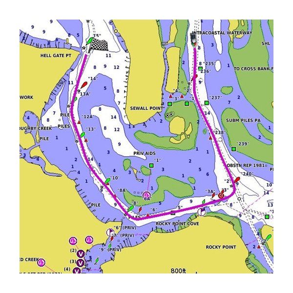
Enjoy excellent coverage and detail while on the water. The Garmin BlueChart g3 HXEU015R Greece map offers top-notch coverage, clarity and detail with updated coastal data as it integrates all Garmin data from BlueChart maps and all Navionics data, giving the user the best navigation and fishing experience. The map also includes automatic route calculation, so you can easily calculate your route and see suggested routes, based on the desired depth, avoiding dry, shallow water, etc.
G3 Greece
Enjoy excellent coverage and detail while on the water. The Garmin BlueChart g3 HXEU015R Greece map offers top-notch coverage, clarity and detail with updated coastal data as it integrates all Garmin data from BlueChart maps and all Navionics data, giving the user the best navigation and fishing experience. The map also includes automatic route calculation, so you can easily calculate your route and see suggested routes, based on the desired depth, avoiding dry, shallow water, etc.
Top Mapping
Offers top-notch coverage, sharpness and detail with updated offshore maps that incorporate content from Garmin and Navionics®.
Automatic Course Calculation
The g3 map quickly calculates a proposed course based on the desired depth, avoiding dry, shallow water, etc.
Depth Shading
Available for up to 10 different depths, it allows you to see the desired depth at a glance.
Level Up to 0.3 Meters
Provides a more accurate illustration of the seabed structure for improved fishing maps.
Shallow Water Shading
Allows shading, at a user-defined depth, for a clear picture of shallow water to be avoided.